
Street planning
Street plans being prepared and approved
A street plan is an official document, subject to the approval procedure in accordance with land use and building regulations, prepared for all streets on the detailed plan area. The street plan must indicate the location, functionality, and connection of the street to the environment.
The City of Hämeenlinna has updated its website in 2026. All street plans approved before that have been removed from the website. In the future, street plans will be available on this page for two years after their approval. Older plans can be requested from urban structure services at kaupunkirakenne@hameenlinna.fi
Public display of street plans
Street plans are regulated by the Land Use and Building Decree. Completed street plans are kept on public display for 14 days. In addition to this page, plans will be available electronically in the city’s public notices and as paper versions at the Kastelli service point for the city center area or at local service points for the surrounding districts.
Public display and the right to submit an objection are announced in public notices and separately by letter to the owners and holders of properties bordering the planned area. The notice is considered to have come to the attention of the party concerned if it has been handed over for postal delivery at least one week before the start of the public display.
Written objections must be submitted by 4:00 PM before the end of the public display period, either by email:
kaupunkirakenne@hameenlinna.fi
or by letter:
City of Hämeenlinna
Urban Environment, Urban Planning
Wetterhoffinkatu 2, 13100 Hämeenlinna.
The objection should include the name of the person submitting it, the name of the street or plan concerned, and the project document number (HMLXXXX/10.03.01.03/xxxx).
Street plans on display or awaiting approval
Environmental artwork for the Turuntie and Olympiakatu roundabout (Sept 21 – Oct 5, 2026)
PLAN DESCRIPTION
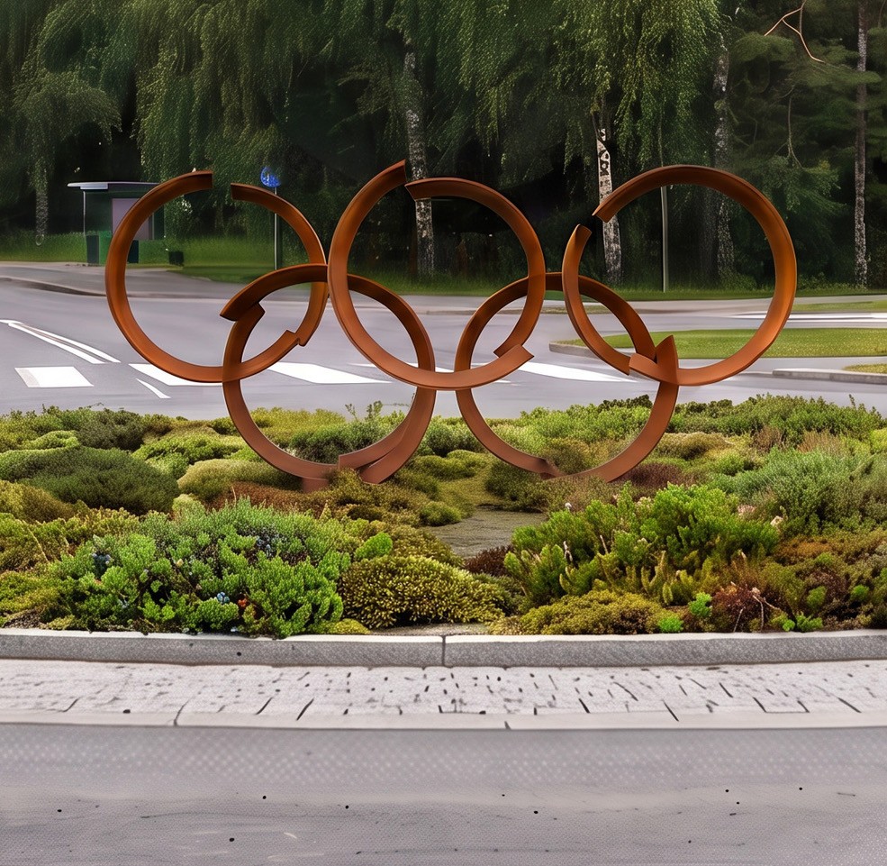
An environmental artwork has been designed for the central area of the Turuntie and Olympiakatu roundabout, highlighting the significant Olympic history of Ahvenisto and Hämeenlinna. The starting point for the work is the 1952 Helsinki Olympics, during which Hämeenlinna served as one of the official host cities and the modern pentathlon Olympic events were held in Ahvenisto.
The goal of the environmental artwork is to create a recognizable and high-quality landmark in the roundabout that strengthens the area’s identity, tells the story of local history, and complements the surrounding cityscape. The purpose of the work is to bring the Olympic heritage into the everyday urban environment in a way that is easily observable yet naturally part of the surrounding landscape. The solution has been designed considering the special requirements of the traffic environment, and its implementation emphasizes durability, safety, and ease of maintenance.
The environmental artwork will be implemented as part of the renewal of the Turuntie street environment. In the project, a new roundabout will be built at the intersection of Turuntie, Olympiakatu, and the new Miekkalinnankatu, and the area’s walking, cycling, and public transport environment will be developed. The goal of the renewal is to create a safe, accessible, and high-standard urban entity, for which the environmental artwork will serve as a visible landmark (May 19, 2026 § 153, HML/121/10.03.01.03/2026).
Concept of the work
The base for the design of the work is the well-known visual language of the Olympic rings, interpreted in a new and distinctive way. The work consists of five separate elements symbolizing the five disciplines of the modern pentathlon and Hämeenlinna’s connection to Olympic history.
The central idea of the work is its changing nature. Viewed from certain directions, the elements align in the view to form a recognizable composition of the Olympic rings. As the viewing direction changes, the whole opens up into a three-dimensional sculptural structure where individual elements stand out as their own shapes. In this way, the work offers different views when approached from different directions and changes with the traveler’s experience.
The design language is intentionally clear and minimalist so that the whole is easily perceivable even from the midst of traffic and from a moving vehicle. At the same time, the work rewards closer inspection by offering new views and interpretations when viewed from different directions.
Materials and lighting
Corten steel has been chosen as the material for the work, which is excellently suited for outdoor spaces and forms a naturally patinated surface over time. The warm brown tone of the material creates a temporal layering and emphasizes the sculptural character of the work. The choice also creates a connection to other new environmental structures and landmarks in the area and strengthens the uniform appearance of the environment.
During dark hours, the shape of the work is emphasized by lighting designed to highlight the forms of the structure and the characteristics of the material. The lighting makes the work recognizable also in the evening and at night and reinforces its position as a landmark in the area.
The work as part of the renewing environment
The central area of the roundabout will be landscaped to be natural and easy to maintain. The vegetation is designed to support the visibility of the work and form a clear, calm background for it without covering essential parts of the work.
Two information boards will be placed near the work along the walking and cycling routes, briefly describing the background and symbolism of the environmental artwork and Hämeenlinna’s connection to the 1952 Olympics. The information boards complement the whole and offer an opportunity to learn more about the history of the site.
The environmental artwork will be implemented as part of the broader renewal of Turuntie traffic environment with the green structures, and public urban space developed for future needs. The new roundabout will become an important junction between Ahvenisto, the city center, and the new hospital area. The environmental artwork designed as the central theme gives the place its own identity and makes Hämeenlinna’s unique connection to Olympic history visible.
Use of the Olympic rings
The design of the work is based on the recognizable visual language of the Olympic rings, which is why the project preparation has involved cooperation with the Finnish Olympic Committee and the International Olympic Committee (IOC). The Olympic rings are an internationally protected emblem, and their use requires the approval of the rights holders.
The goal of the cooperation is to ensure that the work respects the values and history of the Olympic movement and the principles regarding the use of emblems. At the same time, the work highlights Hämeenlinna’s unique Olympic history and makes it a visible part of the everyday urban environment.
The contract package for the implementation of the work is currently being prepared in cooperation with the Olympic organizations. Final approval is expected during this autumn when the IOC processes the technical drawings of the Olympic rings.
Design Agency Siltanen & Sandberg from Hämeenlinna has been responsible for the idea and design of the environmental artwork and information boards.
Miemala residential area 1 (Sept 16 – Oct 1, 2026)
Plan description
The planning area includes Vihtavuorentie between Miemalantie and Talvimäentie, Viljavainionkuja, and Elopellonkuja. The streets are located in Hämeenlinna’s 21st district, Miemala. The streets are part of the local detailed plan 2575 Miemala residential area I, which became legally valid in July 2026. The street class for all streets is residential street, and the maintenance class is 3.
Vihtavuorentie is currently an old narrow road branching off from Miemalantie, which in the is placed in the detailed plan in a 12 m wide street area. The street will be rebuilt for the section covered by the detailed plan. The roadway is designed to be 6.0 meters wide and will be connected to the old roadbed near the Talvimäentie intersection.
Viljavainionkuja and Elopellonkuja are new streets. The width of the street area on these streets is 10 meters. The roadways have been designed to be 6.0 meters wide. The streets are cul-de-sacs, and turning areas have been designed for their ends.
No sidewalks or cycle paths have been designed for the streets.
The width of the roadways allows for parking to be permitted on one side of the road.
The streets are designed with an asphalt surface.
No curbs have been designed for the edges of the streets; instead, a gravel shoulder will be used, over which storm water flows into green swallows built at the street edges. Unabsorbed storm water is collected in storm water manholes. Most of the storm water is further directed to a storm water infiltration structure built in the park area.
The green swallows of the street are designed to be planted with white clover lawn. Deciduous trees and shrubs are planned to be planted at the turning areas of Viljavainionkuja and Elopellonkuja. Small stone dust-surfaced areas have also been designed for both turning areas, where deciduous tree trunks and large stones are planned to be placed.
Plans
Approved street plans
Papinniityntie between Kikaristonkatu and Saarenpäänkatu
Plans were on display from April 13 to April 27, 2026
Plan description
Papinniityntie is located in Hämeenlinna’s 16th district, Idänpää. The planning area begins at the Kikaristonkatu intersection and ends after the Saarenpäänkatu intersection. Papinniityntie is part of the regional cycling route and its functional class is a regional collector street. The roadway and sidewalk of Papinniityntie are currently asphalt-surfaced; there is no cycle path on the planned section.
The width of the Papinniityntie street area between Kikaristonkatu and Heinäjoenkatu is 16.0 m, and between Heinäjoenkatu and Saarenpäänkatu it is 18.0 m. The roadway of Papinniityntie is currently approx. 9.0 meters wide, and the width of the existing sidewalk varies between 2.3 and 2.8 meters. The roadway surface will be renewed with asphalt. A new widened separated sidewalk and cycle path will be built on Papinniityntie. The separated sidewalk and cycle path will be widened towards the roadway and separated from it by a curb. The roadway will narrow to 7.0 meters.
In the separated sidewalk and cycle path, the new cycle path will be two-way, with a lane width of 1.25 meters in each direction. The width of the sidewalk will be 2.0 meters. The cycle lanes will be separated from each other and the sidewalk by painted stripes.
The intersections of Papinniityntie-Kikaristonkatu, Papinniityntie-Laaniitynkatu, and Papinniityntie-Saarenpäänkatu will also be renewed in the planning area.
Plans
Drawing B-16150, the site plan for Papinniityntie, has been updated after objections and approved as such by the Urban Environment Committee.
Lahdensivuntie between Pajakatu and Ansiomäentie
Plan description
The street section is located in the Myllymäki (7) district.
The plan concerns Lahdensivuntie between Pajakatu and Ansionmäentie.
The renovation planning for the street section is driven by challenges in storm water management, the poor condition of street trees, and the lack of modern walking and cycling paths. In addition, the municipal utilities located under the street require renewal. In connection with the street renovation, HS-Vesi and Loimua Oy will renew their own networks.
The roadway of the street will be kept as it is, but it will narrow to 7.0 meters wide as parking pockets have been designed for parking. Central islands have been designed for pedestrian crossings at the Pajakatu and Ansionmäentie intersections. In other parts, pedestrian crossings are designed to be 7.0 meters long without central islands.
A 3.5-meter-wide intermediate band has been designed for the west side of the roadway (Myllymäki side), where bus stops, parking pockets, and some planting are located. Behind the intermediate band, a 4.5-meter-wide walking and cycling path has been designed, where walking and cycling are separated from each other. A grassed green strip about 1.5–2 meters wide remains at the edge of the street area.
On the east side of the roadway (motorway side), the sidewalk designed to be 2.75 meters wide will mostly remain in its current location and elevation, but the surface is designed to be re-profiled by turning the cross-slope away from the buildings. A curb has been designed for the roadway-side edge of the sidewalk. The curb will be lowered so that storm water is directed to the tree-lined avenue. A new tree-lined avenue will be planted on the 3.5-meter-wide strip between the roadway and the sidewalk between Pajakatu and Kanttiinikuja. Between Kanttiinikuja and Ansionmäentie, only a narrow paved strip remains between the sidewalk and the roadway.
All four bus stops on the street section to be renovated are designed as roadway stops, where no separate stop bay is built for the bus; instead, the bus stops on the roadway, as few passengers board the bus here, and there is not enough space for stop bays and waiting areas.
Asphalt is the surface material for the roadway, walking and cycling path, and sidewalk. Intermediate bands without plants will be paved. The curb will be granite.
The elevation of the roadway will rise by 5 cm. The gradients of the walking and cycling path and the sidewalk largely follow the current gradients. The vehicle access points for the plots on the east side (motorway side) will become slightly steeper but will remain below the permitted maximum of 1:8.
The streets have been designed following the basic level of accessibility.
A new network will be built for stormwater, through which stormwater will be directed to current discharge points.
Plans
Drawings B-07115 and B-07116, Map 1 and Map 2 of Lahdensivuntie, have been updated after objections and approved as such by the Urban Environment Committee.
Poltinaho 2, residential area
Plans were on display from April 16 to April 30, 2026
Plan description
The streets are located in the Ahvenisto (9) district.
The plan concerns the following streets: Miekkalinnankatu, Miekkalinnanpolku, Uppalankaari, and Ryytimaankuja.
Miekkalinnankatu is the street leading to the area from Turuntie. Both customer and service traffic to the commercial plot along the street pass through it. The commercial plot is zoned for commercial buildings, where a retail store with a maximum size of 2,500 floor square meters may be placed. The roadway of Miekkalinnankatu is designed to be 7.0 meters wide. The roadway is designed to be bordered by curbs. A 3.5-meter-wide combined walking and cycling path is designed for the south side of the roadway, separated from the roadway by a curb and a one-meter-wide paved strip.
Miekkalinnanpolku is a path intended only for walking and cycling, starting from the end of Miekkalinnankatu and connecting to the walking and cycling path on Hattelmalantie. Miekkalinnanpolku is designed without curbs and with a width of 3.5 meters.
Uppalankaari is a residential street. Uppalankaari forms a loop, connecting at both ends to Miekkalinnankatu. Uppalankaari is designed without curbs and with a width of 5.5 meters.
Ryytimaankuja is a residential street. It connects to Miekkalinnankatu and is a cul-de-sac. Five parking spaces perpendicular to the street have been designed along the street, where, for example, visitors to the adjacent allotment area can park. A turning area has been designed for the end of the street. Ryytimaankuja is designed without curbs and with a width of 5.5 meters.
All streets are designed with an asphalt surface.
Storm water is divided into two different flow directions. Storm water from the southern parts of Uppalankaari and Ryytimaankuja is designed to be directed to the ditch in Taimistonpuisto on the south side of the area.
Storm water from Miekkalinnankatu, Miekkalinnanpolku, and the northern parts of Uppalankaari and Ryytimaankuja is designed to be directed to a new storm water network to be built, through which it will be connected, with retention, to the current storm water network leading towards Kauriala.
Plans
Turuntie between Olympiakatu and Verhokatu
Plans were on display from April 16 to April 30, 2026
Plan description
The planned area is located mainly in the Ahvenisto (9) district.
The plan concerns Turuntie between Olympiakatu and Verhokatu. The plan for the separated walking and cycling path extends near the Taimistontie intersection. The plan also extends to Poltinahontie between Matti Alangon katu and Turuntie, and to Hattelmalantie between Turuntie and Myllymäenkatu.
Roundabout of Turuntie, Olympiakatu, and Miekkalinnankatu
A roundabout has been designed for the intersection of Turuntie, Olympiakatu, and the new Miekkalinnankatu. The diameter of the roundabout’s central island is designed to be 20 meters. The roadway is designed to be 4.5 meters wide, and a three-meter-wide narrowing bordered by a low curb has been designed on its inner side, over which larger vehicles can drive. A separated walking and cycling path has been designed for the outer perimeter of the roundabout. The basic width for walking is 2.25 meters and for two-way cycling 3.0 meters.
Bus stops have been designed in the immediate vicinity outside the roundabout. The stop for westbound traffic is on the west side of the roundabout, and the stop for eastbound traffic is on the east side of the roundabout. The stops are designed to be equipped with shelters.
A separate plan will be made for the center of the circle, which will be brought to the board as a separate matter.
Turuntie
For Turuntie between Olympiakatu and Hattelmalantie, only one 4.0-meter-wide lane in each direction has been designed. Intermediate bands and pull-over space have been designed for the roadway, where it is possible to give way to emergency traffic heading towards the hospital. A turn lane has been designed for traffic turning from the west onto Kruununkatu. The roadway and central islands are designed to be bordered by curbs. Tree-lined avenues have been designed on both sides of the roadway, outside of which separated walking and cycling paths have been designed on both sides of the street, with a width of 2.25 meters for walking and 3.0 meters for two-way cycling.
Intersection of Turuntie, Poltinahontie, and Hattelmalantie
The intersection of Turuntie, Poltinahontie, and Hattelmalantie is designed to be converted into a signalized intersection. Upon arriving at the intersection, separate lanes have been designed for all directions, except for those arriving from the west on Turuntie, where due to space constraints, those driving straight and turning right use a shared lane. The width of the lanes is designed to be 3.5 meters. The roadway and central islands are designed to be bordered by curbs. Along the special transport route on Poltinahontie and Hattelmalantie, some of the curbs are designed to be low, at a maximum height of 6 cm. Separated walking and cycling paths are designed to continue on the west sides of Poltinahontie and Hattelmalantie; sidewalks are designed for the east sides. On Turuntie, west of the intersection, the separated walking and cycling path is designed to continue on the north side of the roadway, connecting to the current separated walking and cycling path on Turuntie. A sidewalk has been designed for the south side of the roadway.
Other
The planning area is mainly on the target network for a special level of accessibility, so most of the changes have been designed according to the special level of accessibility.
All streets are designed with an asphalt surface. On the Turuntie section, the cycling parts of the separated walking and cycling path are designed with red asphalt.
Storm water is designed to be directed to the current storm water network, which is largely planned to be renewed.
Plans
Kukostensyrjäntie, Kanukkakuja, Hanhikkitie, and Kuusamakuja
Plans were on display from June 11 to June 25, 2026
Plan description
The planning area includes Kukostensyrjäntie, Kanukkakuja, Hanhikkitie, and Kuusamakuja. These streets are located in Hämeenlinna’s 32nd district, Ruununmylly. The streets in the planning area are gravel-surfaced.
Kukostensyrjäntie is a residential street bordering Kikaristonkatu and Papinniityntie. The width of the street area is 10.0 meters. The current roadway width of Kukostensyrjäntie varies between 4.0 and 5.5 meters. The street will be renovated in its entirety to be approx. 5.5 meters wide. The roadway surface will be renewed and updated to asphalt. A curb will be installed for part of the way to prevent storm water from flowing onto properties.
Kanukkakuja is a dead-end residential street starting from Kukostensyrjäntie. The width of the street area is 10.0 meters, except for the wider turning area at the end. The current roadway width of Kanukkakuja is about 4.5 meters, and the street will continue to be renovated to be 4.5 meters wide. The roadway surface will be renewed and updated to asphalt. The roadway will be sloped one-sidedly to the east edge. The current swallows at the edges of the street will be preserved and, if necessary, built into a continuous structure.
Hanhikkitie is a residential street bordering Kukostensyrjäntie and Papinniityntie. The width of the street area is 10.0–12.0 meters wide. The current roadway width of Hanhikkitie varies between 3.5 and 4.0 meters. The street will be renovated in its entirety to be 4.5 meters wide. The roadway surface will be renewed and updated to asphalt. A curb will be installed for part of the way to prevent storm water from flowing onto properties.
Kuusamakuja is a loop-like residential street connecting to Kukostensyrjäntie. The street area is an exceptionally large area where the Kuusamakuja roadway forms a loop, with a green area in the middle. The current roadway width of Kuusamakuja is about 4 meters. The street will continue to be renovated to be 4.0 meters wide, but the curves will be made wider. The roadway surface will be renewed and updated to asphalt.
On the 5.5-meter-wide residential streets (Kukostensyrjäntie), parking will be permitted on one side of the roadway, which will be determined in the traffic control plan. Grass will be planted on edge areas of the streets as they are now.